Laser scanning: creation of digital twins
Laser scanning is a technology of the measurement of distances and angles to the points of laser beams reflections and the calculation of the coordinates of these points. The result of laser scanning is points cloud which is then used to build spatial 3D models of the object.
There are 3 types of laser scanning:
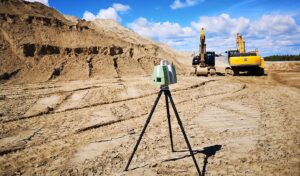
1. Terrestrial Laser Scanning – performed from a static installation. This type is suitable for enclosed spaces, complex structures and internal surveys. It is used in geodesy and mining geodesy, construction and operation of engineering structures, architecture, industry, road infrastructure construction, monitoring of buildings and structures, etc.
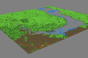
2. Airborne Laser Scanning is carried out from an aircraft. This type of survey is very well suited to hard-to-reach and hazardous sites, and also has a significant advantage over standard aerial photography by effectively measuring the topographic height and density of vegetation.

3. Mobile Laser Scanning (MLS) – Depending on the subject to be surveyed, the laser scanner can be mounted on a land, water or other medium. MLS is predominantly used for surveying roads, railways, bridges and other objects in the terrain.