
Development of geoinformation systems
Geographic database
Up-to-date information resources are stored in databases. A geodatabase is the primary data format used to edit and manage the data, which consists of geographic information available in various formats in the geographic information system. Geographic information is used everywhere, in almost every aspect of industrial production and people’s daily lives.
Data may help improve the data management by providing the public with the more detailed information and support economic growth by enhancing resource planning system and thereby improving decision-making.
Geodatabases have a comprehensive information model to display and manage geographical information. This comprehensive information model is implemented by a series of simple data tables (Figure 1) containing spatial feature classes, raster sets and attributes.
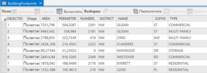
Figure 1 Table with data
Geodatabases come in different sizes, have different numbers of users and can scale from small single-user, file-based databases to larger workgroups, departments and enterprises that are accessed by many users.
The database design is based on series of data themes, each with a specific geographical representation. The geographical representations are arranged into series of datasets or layers (Figure 2). A set of themes works like a set of layers. The geodatabase can contain geographic data in four representations:
- Vector data to represent spatial objects.
- Raster data for network and surface data representation.
- Triangulated Irregular Networks (TIN) for surface representation.
- Addresses and rangers to find the geographical location.
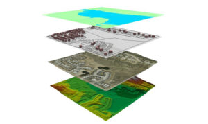
Figure 2 Thematic layers
The advantage of the geodatabase is as follows:
- The way data are stored and processed.
- Data access rights.
- Data storage capacity.
Geodatabases (Figure 3) are the backbone of spatial data infrastructure. Their content cannot be reduced to geographic information only. It is much broader than that. Geodatabases are the basis for storing spatial information resources and the basis for generating new information resources.
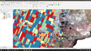
Figure 3 Geodatabase
AlmatyGeoCentre LLP provides geodatabase development services. The range of their application today is immense. Data is an integral part of professional activity of a modern person, so it is very important to process it efficiently. Unified placement and protection of all types of information helps to significantly reduce the cost of storage devices.